Forest change monitoring using satellite image time series
Jan Verbesselt, 2016-02-01
Loïc Dutrieux, Ben DeVries, Johannes Reiche, Lammert Kooistra, Martin Herold, Brice Mora
Laboratory of Geo-Information Science and Remote Sensing
Wageningen University, The Netherlands
Why do we want to keep an eye on the forests?
"Changes in forest cover affect the delivery of important ecosystem services, including biodiversity richness, climate regulation, carbon storage, and water supplies"(Foley et al. 2005; Hansen et al. 2013)
Forests are constantly evolving
Between 2000 and 2012, 2.3 million km² of forest were lost and 0.8 million km² were established (Hansen et al. 2013)
Challenges in remote sensing forest change tracking
- Detecting change in time-series is not that straightforward
- Scale and intensity of disturbances vary
- Anthropogenic changes can be confused with natural variablility
- Cloud cover reduces data availability... sometimes a lot!!!
How do we detect change in time-series?
BFAST framework for change detection
- Verbesselt et al. 2010a,b, 2012
- Models vegetation annual behaviours
- 2 modules
- Near real-time change detection (bfastmonitor)
- Full time-series segmentation (bfast)
bfastmonitor
- Near real-time change detection
- Detect deviation from a stable regime
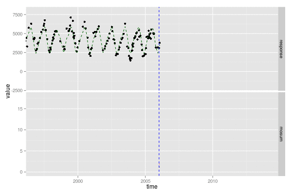
Verbesselt, J., Zeileis, A., & Herold, M. (2012). Near real-time disturbance detection using satellite image time series. Remote Sensing of Environment
bfast
- Iteratively decomposes time-series into trend, seasonality and remainder
- Segments time-series into segments and breakpoints (abrupt and gradual change)
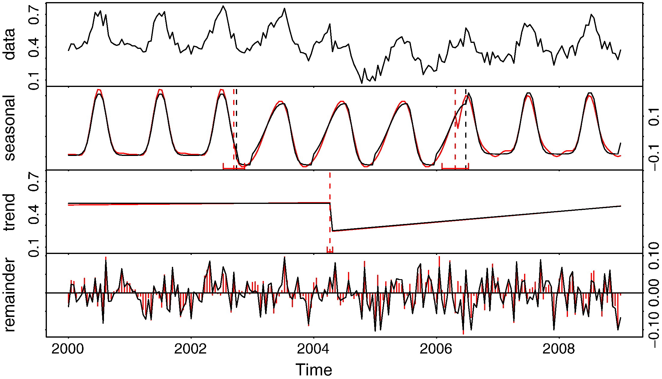
bfast example
Shifts in land use regimes
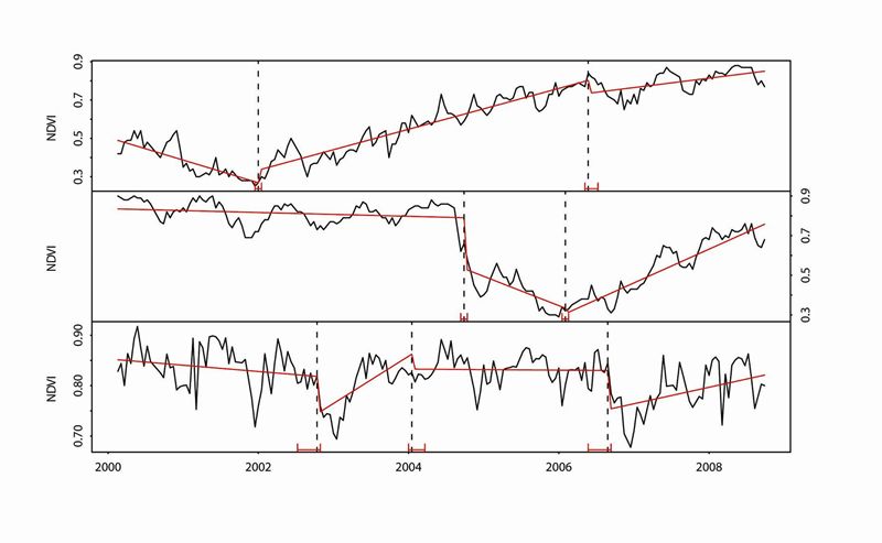
Verbesselt, J., Hyndman, R., Newnham, G., & Culvenor, D. (2010). Detecting trend and seasonal changes in satellite image time series. Remote sensing of Environment
Available as an R package
bfast packageExamples of applications
Change detection and monitoring research research task
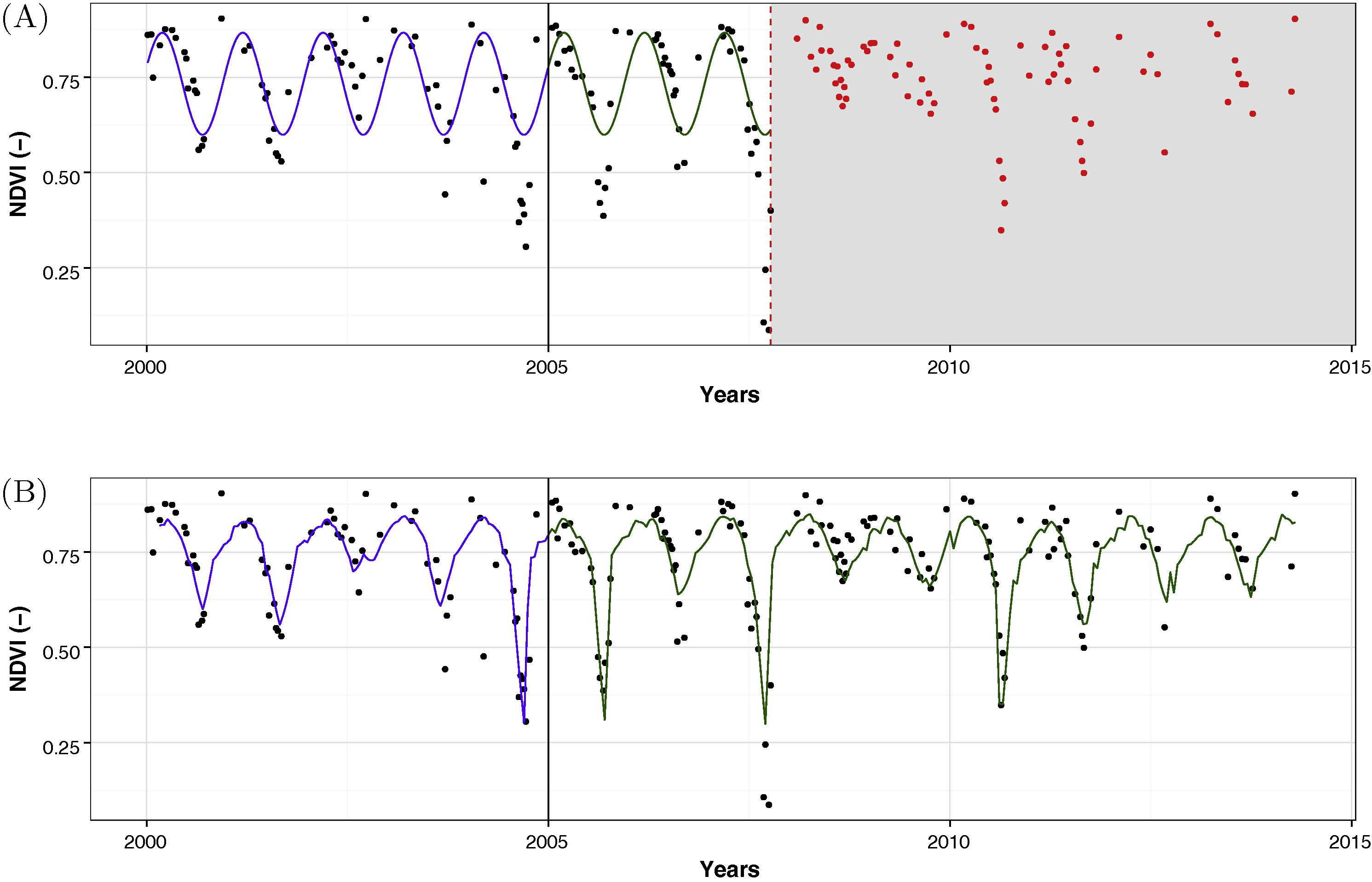
Monitoring small-scale forest disturbances
Monitoring small-scale forest disturbances
- Use bfastmonitor with Landsat time-series
- Combine significant change with change magnitude to detect small-scale disturbances
DeVries, B., Verbesselt, J., Kooistra, L., & Herold, M. (2015). Robust monitoring of small-scale forest disturbances in a tropical montane forest using Landsat time series. Remote Sensing of Environment
Monitoring forest cover loss using multiple data streams
Monitoring forest cover loss using multiple data streams
- Uses MODIS NDVI as external regressor in the change detection process
- Takes advantage of the scale difference between natural and anthropogenic disturbances
Dutrieux, L. P., Verbesselt, J., Kooistra, L., & Herold, M. (2015). Monitoring forest cover loss using multiple data streams, a case study of a tropical dry forest in Bolivia. ISPRS Journal of Photogrammetry and Remote Sensing.
SAR-optical fusion for deforestation detection in the tropics
SAR-optical fusion for deforestation detection in the tropics
- Fused Landsat and PALSAR (L-band SAR) time series
- Increase in spatial and temporal accuracy with high cloud cover
Reiche, J., Verbesselt, J., Hoekman, D., & Herold, M. (2015). Fusing Landsat and SAR time series to detect deforestation in the tropics. Remote Sensing of Environment
Tools
- bfast R package
- bfastSpatial R package (training session on Friday)
- timeSyncR R package
A change map in 3 lines of code
Conclusion
- Forest dynamics can be difficult to capture using satellites
- We've developed and tested different approaches to tackle forest change monitoring in various environments
- ... And we keep working on it (forest regrowth, land use intensity, etc)
- We've developed free (as in speech and in beer) tools for everyone to use
- Use them and let us know what we can improve
Thanks!
http://changemonitor-wur.github.io/talks/change-detection-2016
Original presentation prepared by Loïc Dutrieux